Tuesday, December 30, 2014

More little hikes in the Coromandel

After the requisite stop at the Whitianga I-Site and armed with our trusty map friendly local travel suggestions, we drove around the north Coromandel Peninsula and went on 4 small hikes.

Hike 1:  Rings Beach at the start of our hike...

...and from the lookout above the beach


Pohutukawa tree, known as the NZ Christmas tree because it blooms red in December

 Scenic lookout from a pullout at the peak of the northern crossing of the Coromandel

Hike 2:  Taumatawahine walk known as a ponga bush walk

Flowers along the way

 Hike 3:  Tokatea Lookout
This site was used for marine surveillance during WWII

Kennedy Bay lookout

Hike 4:  Papa Aroha walk which goes through coastal forest...

 ...and ends at the beach

Life is good!!!

And the next day, 3 more hikes:  One on the lovely beach in Whitianga (no pics).  The second had these views:

 Waitaia bush walk


I can't get over the pristine ferns--incredible colors and feathery textures 

Fern varieties I've never seen before

and for the third, we had to take a 10 minute ferry across Whitiangi Bay from the wharf near downtown to see:
 
Whitiangi Bay

Cliffs above the bay  

 Maramaratotoara Bay

We ended with a well-deserved ice cream break.

 Me with our our favorite NZ ice cream, Tip Top!


Sunday, December 28, 2014

Lake Taupo and Coromandel Peninsula

On Christmas Eve, while the town of Taupo was shutting down for the holiday, we went to the lake and took a 2-hour boat ride to see some unique Maori rock carvings.  There were 50 people on board our boat and we really enjoyed the relaxing ride which went around the NE side of the lake.

 The Ernest Kemp, 30 years old and a replica of an historic vessel

After our complimentary glass of wine and a few snacks, we came upon the carvings.  Some are over 10 meters high and only accessible by water. The carvings may look like the remains of an ancient Maori village but were in fact created in the late 70s by a master carver as a gift to Taupo.

 This is the largest carving of a high priest and great navigator in the 13th century

 These represent guardians who protect the carvings

 This lizard is also called Protector

On Christmas day, while most everything in town was closed, we went to de Bretts Day Spa.  Was this ever relaxing!  There are 3 outdoor mineral pools to choose from: very hot, hot and cool.  Ahhhhh.....we just loved it.  And with our day pass, we were able to return at the end of the day.  This time, we soaked in a hot private pool.  Super ahhhhh.....

de Bretts day spa

Carving at the spa

Sculpture carved out of the bottom (pun intended) of a fern tree

Me soaking in our private hot pool--Happy Feet

So on the 26th, we said our goodbyes to Taupo and worked our way north to our next destination, the Coromandel Peninsula.

We stopped for two very pretty, short walks along the way.


 Hamurana Springs river walk

 Clear, clear water with visible rocks below

Redwood grove--these trees were brought from California and planted around 1900

Hamurana Spring--a source that starts here and flows downstream into Lake Rotorua

The next hike was to Okere Falls:

 Okere Falls

 Kayakers at the bottom after their ride down the falls

The Coromandel Peninsula (about 3 hours east of Auckland) is a popular vacation spot for locals with many beach towns along the coast.  We are staying in Whitianga (pronounced Fitianga in Maori) on the NE coast.

Now that's it's summertime, there are many activities in these towns including farmer's markets and craft fairs.

 Whitianga Fair

 Rope art

An insurance company at the beach was promoting good health and as a promotional stunt, had an obstacle course.  If you did the course, you could get a free tee shirt/sunscreen and sunglasses.  Free stuff!   Let's do it!

 Commando!

 
 Cowabunga!

The winners with their free booty!
Another activity we missed 5 years ago was going to Hot Water Beach, which needs to be visited during low tide. We were so lucky to have another chance this time to catch the low tide right  This is a beach that has underground hot springs which filter up through the sand and are exposed only during low tide.

Equipped with a shovel and towels provided by our motel, we were on our way.  And we were not alone!

This is a great destination all year round, but especially busy in the summer

What happens is this:  you start digging around, looking/feeling for warm spots (some spots would burn your feet).  Once you find a spot you dig, dig, dig and sometimes the cold ocean waves come in and destroy all your hard work.  But finally, the tide is low enough, the waves stop their destruction and you can finish digging and just sit and enjoy the warm water.

 Busy digging pools and building walls to keep the ocean waves out

 Miles and new friends digging

Ahhhhhhh......

Monday, December 22, 2014

Lake Taupo and Tangariro Alpine Crossing

Time to explore Great Lake Taupo (pronounced Toe-Paw.  To see and hear how to pronounce Taupo,  go to this cute video www.youtube.com/watch?v=yg9tvuE3K0w).  This lake is BIG:  surface area of 616 square km--238 sq mi.  (To give you an idea how big, Lake Tahoe's surface area is smaller with 490 square km--191 sq mi.) 

The weather was wonderful so what better way to see the lake close up than to rent bikes.  We rode for about an hour each way on a terrific bike path and covered only a fraction of the lake.  It was BEAUTIFUL! 

 Wild flowers along the shore

 Inlets along the lake

 Black swans with red beaks

 This thermal stream was HOT and the lake water COLD

Taking a break during our ride--the black sand looks like coarse ground pepper 
and gets HOT in the sun

And now for our BIG adventure--TONGARIRO ALPINE CROSSING!  When we were in New Zealand 5 years ago, we vowed that if we ever got back here, we'd do the Tongariro Alpine Crossing, about a 1 1/2-hour drive from Lake Taupo.  This trek is considered the best 1-day hike in all of New Zealand. It is 19.4 km and takes about 7 hours. It is also considered a 5 (with 5 being the most difficult).  As one guide told me, this is not a hike for the faint-hearted and has very steep ups and downs.  We were psyched for the challenge!
This hike is very popular and there are many transportation companies that take you from your motel to the starting point of the trek, pick you up at the ending point and return you to your motel.  What a pleasure not to have to worry about driving!  This hike is very weather-dependent and you have to check the forecast the day before.  This is an alpine pass that can be very windy and rainy/snowy and is often closed even in the summer.  Although the prediction a few days before was RAIN, we were very lucky and the day we went was beautiful--very little wind, no rain and about a wind chill factored temperature of about 12 -15 degrees C.

So the bus picked us up at 6:30 am and were on the trail by 8:15.   Joined by LOTS of other hikers (99% younger than us--no joke), we started up the mountain.  Well, I can tell you, it was hard going for me and I had to stop frequently on this first ascent.  (I've been doing Zumba for years and I thought I must be in pretty good shape, right?  Well, Zumba goes only so far--I think age must also be a factor and the hike was HARD!  It was not easy for Miles either). No matter!  Encouraged by my hike-motivater (Miles), up, up, up we went step-by-step and before long, we were at the ridge of an incredible volcano.  This whole region is volcano-rich and the views were amazing.  In general, the air was so fresh--like being on top of the world.

 On the ascent to the edge of the red crater with Mt. Tongariro in view 
 
On the edge of the red crater
Great lava formation

Lava and volcano

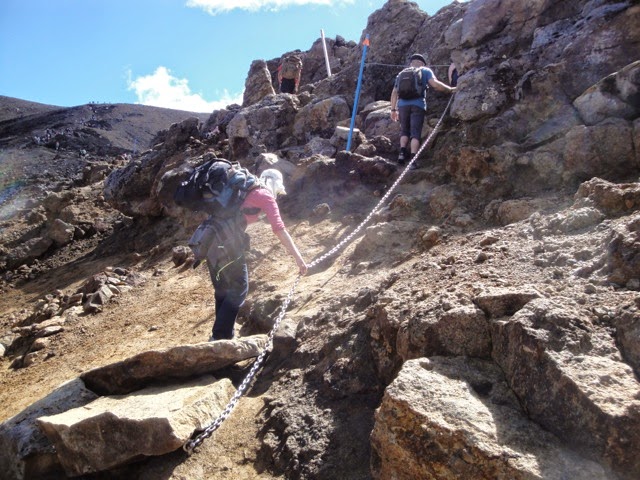
We continued with a hard ascent towards the summit of the red crater.

 
Me going up an ascent with the help of a chain attached to the rocks 
After a quick lunch break, and small ascent to the summit of the red crater, we started our 
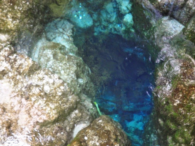
descent down a very gravelly path to the emerald lakes and blue lake with the most incredible colors. Lots of slipping and the best way down was a kind of side-step slide. Going up is hard aerobically and going down is murder on your knees.  In some places we also smelled the sulfur fumes (i.e. rotten eggs) of the volcano.

Slippery descent to the emerald lakes and blue lake
 Blue Lake

 Overlooking the Emerald Lakes
On we went!  The last part of the trek was a long descent (a couple of hours) of constant downhill on a path (now my toes were smashed and hurting).  In 2012 there was an eruption that damaged the Ketetahi Hut. Luckily, no people were in the hut at the time.  Later we passed a thermal vent that had been created in this eruption. 


Damage to the Ketetahi Hut

Steam coming from a fumerole
 We saw some patches of snow...

 ...and this little snowman with Lake Rotoaira Lake Taupo in the distance
From extremely desolate lava mounds up top, we hiked down through many levels of vegetation, returning to a tropical forest and winding up at the end of the trek around 3:15pm.  Finished!  And still alive!  But oh, my aching feet!
 Signs of life on the descent

This was a thrilling and exceptional adventure and we're both so glad to have been able to do it!